Wreck One June/July 2016 Project.
Page 3
Some of the team were also monitoring the plotter and the small Hummingbird scan and some were monitoring the Toughbook with the images from the Sportscan. There was also a member of the Team who was ready to deploy a visual marker on site which would be deployed once an interesting target was located. The Imagenex program enables a clear picture of the seabed to be created. The sand gullies can clearly be seen as well as any rocks or items on the sand. The shadows created by the scan enable the Team to calculate the height of the objects. On the patch reefs, gullies and outcrops can be clearly seen. The yellow dashed centre line shows the boats position in respect of the items on the port and starboard side. The distance between the centre line and the object shows how much water is between the fish and the object, in some cases it got very close.
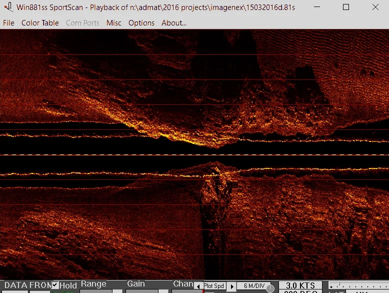
A detailed screen grab from the Imagenex Sportscan Side Scan Sonar, as the sensor goes over a patch reef with the sensor nearly hitting the reef
After two weeks of running grid lines back and forth the Team found nothing that resembled the target that Dr. Spooner and Jeremy Schomberg found in 2005. We tested the functioning of our equipment by deliberately running over several charted, known, reefs, and these reefs showed up very well on both the Imagenex and Hummingbird Side-Scan-Sonars. The Team went back to our notes and documented the following possible reasons why up to this point the equipment was not able to find this wreck.
- We may have made the search area too small
- The survey grid lines may have been spaced too far apart.
- The boat may have been moving too quickly for our sonars to paint a clear picture, especially when travelling from east to west with the prevailing wind (scanning speed typically should not exceed 5 km/hour).
- The signal “noise” of the ~2 meter-high (peak to trough) waves we experienced could have caused us to miss the ~2 meter-high shipwreck signal.
- Natural forces such as hurricanes, sedimentation, earthquakes, etc. since 2005 (taking into account the magnitude 7.0 Haiti earthquake which occurred on 12/01/2010 at 16:53, local time. The earthquake killed between 46,000 and 316,000 people and caused total devastation. ADMAT's Maritime Archaeological Centre in Monte Cristi was dammaged by this ) could have caused a) the shipwreck to settle deeper into the sea floor, or b) the sea floor to rise, leaving less of the shipwreck visible above the bottom.

Showing the immage as the sensor goes over a patchreef on the left and sand dunes on the seabed on the right

Showing a complex coral reef with gullies and outcropts
Please go to page 4 to continue.
ADMAT's maritime archaeological work on this wreck site was assisted by ADMAT-FRANCE a non profit organisation based in the Institut de Paléontologie Humaine, Muséum National d’Histoire Naturelle, Paris.
ADMAT-FRANCE is a sub division of the Anglo ~ Danish Maritime Archaeological Team
ADMAT is delighted to have an association with Muséum Nationald’Histoire Naturelle at Paris, départememt Préhistoire, UMR-CNRS 7194.